Features TotalMapper
Map and navigation application with many functions for all mountain activities.
The application can work with GPS devices and smart watches such as Garmin, etc.
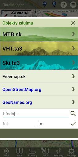
Integrated MTB - VHT - SKIALP guide:- descriptions of MTB routes within Slovakia.- descriptions of Tatra hikes on the border between hiking and mountaineering.- descriptions of Tatra ski mountain tours.MAPSThere are many maps of the world based on OSM.
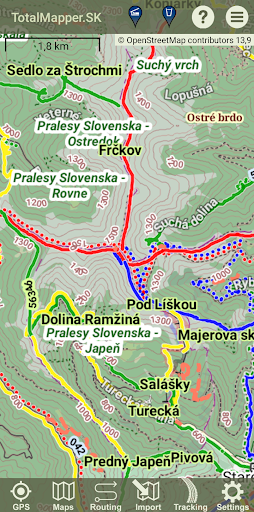
All maps can be downloaded offline, thus gaining independence from the Internet.
It is possible to adjust the font size for the mobile screen and visual disposition of the user.
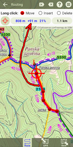
Of course, the choice of map orientation is also in the direction of travel or according to the compass.The latest versions allow you to use Strava heatmaps as a map layer, which opens up new possibilities for planning and finding the optimal route.The following maps are currently available for selection:Europe EU Freemap.sk/cyclo EU Freemap.sk/tourist CZ Cykloserver.cz ES IGN.es FR BRGM.fr FR IGN.fr SK Cykloserver.cz SK NLC.sk/forest roadsWorld WW BergFex.at WW Cykloserver.cz WW Mapy.cz WW OpenCycleMap.org WW OpenStreetMap.org WW OpentTopoMap.org IL IsraelHiking.il/hiking IL IsraelHiking.il/mtb NZ NZTopoMaps.comStrava heatmaps WW Strava/bike WW Strava/runOpenAndroMaps WW vector mapsNAVIGATIONThe application provides all the functions you need in the terrain, including voice navigation and tracking progress according to the height profile.ROUTING - route planning + GPX editorIt searches for a route from point A to point B with the choices ROAD - MTB - HIKE - RUN.
The route is calculated on the OpenStreetMap or MapQuest servers.
It is also possible to use the comfortable GPX editor and click or edit your own route.
A height profile is automatically generated.
Distance and slope can be measured.OBJECTS - points of interestThe application can display various types of objects on the map, such as accommodation and restaurant facilities, water sources, cultural and historical objects, etc.TRACKING - route recordingThe application records the route traveled.
In addition to GPS coordinates, the recording also contains information about time and altitude.
It is possible to add your own points on the route (so-called trackpoints) to the record, which in addition to the name, can also contain photos.DASHBOARDIt is possible to call up a Dashboard with similar functions as a cycle computer:- total time- distance traveled- climbed height meters- height above sea level- maximum altitude- instant, maximum and average speedMAP PORTALS AND SOCIAL NETWORKSThe application accepts the GPX format, which is supported by all well-known web map portals.
It can be used when planning a route, as well as viewing a recorded route.
The application is able to share traveled routes on social networks such as FB, Strava, etc.
Social Features
Connect and share with friends and the community.
Gaming Features
Enjoy immersive gaming experience with various game modes.
Camera Features
Advanced camera features with editing capabilities.
See the TotalMapper in Action
Get the App Today
Available for Android 8.0 and above